The early history of our school is naturally tied up with the fortunes of the district and the availability of transport systems. In the 1840s Old Cleveland Road was only a track from Cleveland (named after the Duke of Cleveland, the Secretary of the Colonies) to the rather fragmented settlement of Brisbane. Farmers from Cleveland, Redland Bay and Mount Cotton used this track as did the teamsters hauling cargo to and from the port of Cleveland. They would camp overnight in a gully at the bottom of a hill near a small stream where their animals (bullock teams, mostly) could be watered. This location today is where Bennetts Road meets Old Cleveland Road and leads directly to the name, ‘Camp Hill’.
First Nations were considered a problem in the early times and after sunset were prohibited from entering the ‘town area’. A series of ‘boundary posts’ were set up and the First Nations were not permitted to pass these after dusk. Later, these demarcation lines became the names of thoroughfares – hence, ‘Boundary Road’. Woolloongabba (Wulungar-bah) was a recognized fighting ground while corroboree grounds were located about three kilometres from the school site and First Nations freely roamed the Camp Hill district.
Between the 1850s and the 1870s Camp Hill was a patchwork of vineyards and dairy farms. Many settlers were German immigrants who had either received land grants or purchased their land at 2 shillings and 6 pence (25cents) an acre. About 1880 land rose in value but the 1893 floods were devastating to the area as approaches through Stones Corner and East Brisbane went under water. Land values did not recover until 1912.
In the late 1880s the building of a railway was planned. The route surveyed would have brought the line through the Camp Hill district. The idea was to take the line behind the present Coorparoo School and follow the pioneer track along the gully. There was great opposition from the Coorparoo and Norman Park areas and in the subsequent dispute, Camp Hill and Belmont, where the proposed line would come to, lost out. Not only was the line lost but when the other route was opened in the early 1890s, the main coachline was eliminated. A Mr S. Winterbottom started a ‘bus service’ to Coorparoo and then ran a wagonette to Belmont as a feeder service. The fare was about nine pence (8 cents). He later sold the service to Mr H. Dean who ran it till the late 1890s. The district was then without public transport until 1912.
In 1912 the Belmont Flyer (a locomotive with two carriages) commenced operation.
This branch line ran from Norman Park, up to and around Skyline Drive to about the bowling-green on Ferguson Road, across Perth Street (near Glindeman’s Dairy) and on to the junction of Halland Terrace and Wiles Street. It then cut across the reserve (the site of the current Junior Campus), to where Little Ferguson Road runs (past Day’s Dairy), then up along Old Cleveland Road (past the Belmont Public House) to where the wool scouring works were established on Bulimba Creek near the bridge on the Carindale housing estate. At the end of the journey the train would be turned around on a rise to the left of Old Cleveland Road outbound.
The train would stop at any of the tiny stations along the way including Seven Hills, Mt Bruce, City View, Mayfield, Carina, and Belmont. The fares varied from about one penny to threepence (1 to 2 cents) with rarely more than one hundred passengers a day. Word has it that at the end of the day on the last train back to South Brisbane, the crew would stop at Glindeman’s for a cup of tea, much to the irritation and frustration of the passengers who just had to wait.
Owned by the Belmont Shire Council, the railway line was some 6.2 kilometres (4 miles) long and cost around $40,000 (£20,000) to build. Constructed against the advice of the Commissioner of Railways, the line was actually called the Belmont Tramway, effectively by-passing a regulation preventing local Shire Councils from operating railways.
The line was closed in April 1924 and the Shire Council asked the Railways Department to take over the Flyer. The offer was rejected. However, the people succeeded in having the route reopened in May 1925 but time and white ants had wreaked havoc. It cost, in today’s money, close to $1,400 to recondition the tracks but when the Greater Brisbane Council was formed, it swallowed up the Belmont Shire and permanently closed the line in October 1926. During its operation the Belmont Flyer had shown an annual loss of $12,000.
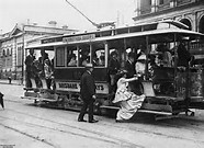
In 1925 the tram line (not to be confused with the train line) was extended from Coorparoo Junction to the terminus at Bruce Street – a distance of one mile and four chains. It was a single line with a loop at Bennetts Road. On the afternoon of 10 January free rides from The Junction to the Bruce Street terminus were available with two of our school’s future first day pupils holding the ribbon for the first tram to pass. It wasn’t till 1949 that the line was extended to Belmont.
Around this time the Brisbane Courier in its June 1926 paper reported that you could walk from Hill End over Highgate Hill to Burnett Swamp (Stones Corner) without seeing more than a dozen houses.
The school area is reportedly part of the catchment area and the headwaters for Perrin Creek. In 1926 there were still several deep holes in the creek at the bottom of the hill near Valaria Avenue that were ideal for swimming and yabbying with the local women using the creek water for washing in times of drought. Apparently, Kangaroo Gully as it was called was a favourite play spot for the children of the area.